Duration: 25 days trek and 5 day culture tour.
Locations: Paro, Thimphu and Punakha valley . Tashithang,Damji, Gasa,Chamsa,Laya,Rhodophu,Tarina,Wache,Lhedi,Thanza, Tshochena, Jichu DramoThampe Tsho and Maurothang trekking.
Highlight: The Snowman Trek is an extension of the beautiful Laya Gasa Trek, and leads from Laya further into the high altitudes of the Bhutanese Himalayas. It takes tough and enduring trekkers into the Lunana region and further on to Gangkhar Puensum and Bumthang or down to Sephu in Trongsa district, depending on which route you choose.
The Snowman trek leads through the most remote areas up to very high altitudes. Trekkers have to camp in altitudes above 5,000m more than once, and depending on the seasonal temperatures, the camps are sometimes on snow.
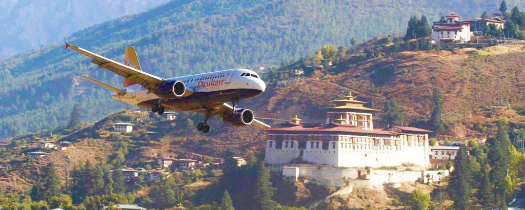
As the plane approaches Bhutan, if you look down farmhouses as dots on the hillsides can be seen. As the aircraft enters the Paro valley, you will see Paro Dzong on the hillside overlooking the ParoChu (river), with Ta Dzong, formerly a watchtower and now the National Museum, above it.
You will be received by the representative of Yelha Bhutan tour & Travels who will be your Bhutan travel guide throughout your tour.
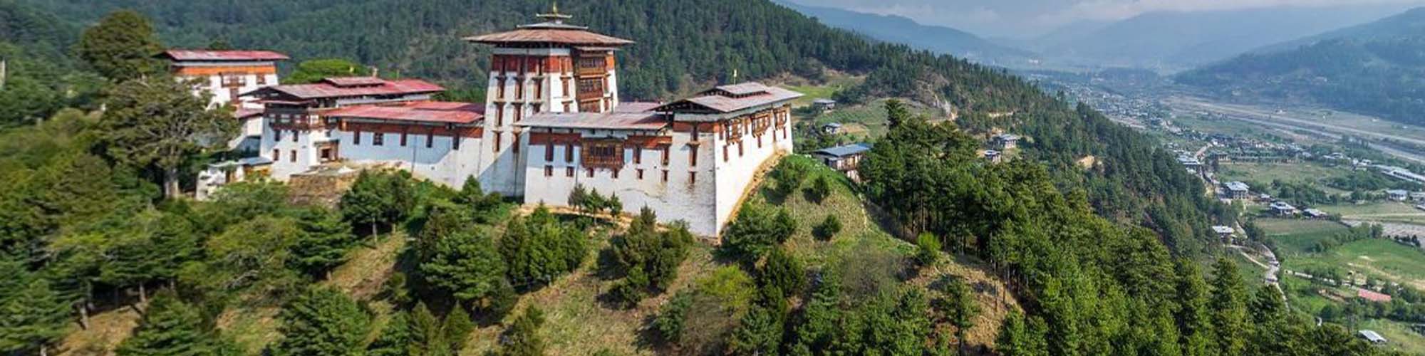
After arriving Paro, check into the hotel and rest for a while and then visit Paro Rinpung Dzong and National Museum of Bhutan which is also called Ta-dzong (the watch tower).
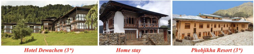
Overnight in hotel/resort at Paro
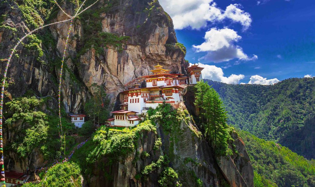
After breakfast, drive up to the base camp of Taktsang and then hike up to the most famous Monastery in the entire kingdom of Bhutan perched on the edge of a steep cliff, about 900meters above Paro Valley. The hike to the viewpoint will take about an hour and it will take 2hours to the monastery. Till view point, you can experience horse ride by paying USD 15 to USD 20 per horse but if you prefer hike, then it is great.
Lunch at Taktshang Café just above view point or you can have picnic lunch.
After completing the hike, you will be visiting one of the farm houses in Paro to experience Bhutanese life-style and the organic Bhutanese dinner. You can also experience hot-stone bath at farm house (US $ 20 per person).
Drive up to Drukgyel Dzong (2,580m) where the road ends and the trek begins. With a gradual climb the trail follows the Paro Chhu passing beautiful meadows, paddy fields and impressive farm houses. After about four hours you will reach the army post at Gunitsawa village.
At the army check post your trek permit (provided by your tour operator) will be checked and endorsed. The campsite is on the opposite side of the river, not far from Gunitsawa.
On this long day, the trail continues with lots of small ups and downs. After going uphill through the river valley, you enter the Jigme Dorji National Park. The valley finally narrows gradually to a mere path, which descends to a meadow where a camp will be set up. From here, if weather permits, you will have the first great view of Mount Jomolhari.
If you did not see Mount Jomolhari last evening, you will have a great chance to get a great view this early morning. This morning the trek continues up the Paro Chhu valley, which widens into patches of alpine meadow and scanty growths of forest. Cross an army outpost along the way and enjoy a spectacular view of high mountain ridges and snow-capped peaks. Yaks and the herder’s homes become a regular feature of the landscape.
Passing the villages Soe, Takethang and Dangochang is another asset on this day. Reaching Jangothang, one of the most beautiful campsites of the Himalayas, you will again have a spectacular view of Mount Jomolhari.
The day in Jangothang provides plenty of possibilities for day hikes with great views on lakes and snowcapped mountains such as Jomolhari and Jichu Drake. There are good chances to spot some blue sheep on the upper slopes of the valley. Jangothang is a perfect environment for your acclimatization. Trek up to Tosoh or hike around the area.
There are good short hiking trails in three directions. Jumolhari and its subsidiary mountain chains lie directly west, Jichu Drake to the north and a number of unclimbed peaks to the east.
fter 15 min. from the camp the trail climbs rapidly for about half an hour and then becomesa gradual ascend to the Nyilila pass at 4,870m. While on the climb enjoy the surrounding. You might see herds of blue sheep grazing on the slopes of the mountains. From the pass you will have spectacular views of Mt. Jomolhari, Jichu Drake and Tsherimgang, all of them
rising above 7,000m.
On the way down to the camp you will pass by some of the yak herder’s tent, made from yak wool, where the herders take shelter while on the move to various
pastures for their yaks. As you come down into the Lingshi basin, you get a wonderful view of Lingshi Dzong on a clear day. Tserimgang and its glaciers rise up at the north end of the valley. The campsite is next to a stone hut you reach just before Lingshi Dzong.
Today is the shortest walking day, and you can really take it easy. Shortly after starting you will reach a chorten below Lingshi Dzong. Here, you have the choice of staying on the main trail or taking a diversion up to the Lingshi Dzong (4,220m), which sits right atop a ridge.
Besides a very special atmosphere of mystic silence Lingshi Dzong provides a great view over the valley. After Lingshi Dzong you will be passing the villages of Lingshi and Goyul. In Goyul, the stone houses are clustered together to a small compact village that is unusual in Bhutan where village houses are normally scattered.
On reaching the campsite at Chebisa with a beautiful waterfall behind the village, you will have plenty of time to visit the village houses if you feel up to it.
You walk through a wide pastureland towards Gobu La (pass). On the way, you will see a few people herding yaks. There is also a great chance to spot large herds of blue sheep above the trail.
After crossing the Gobu La (4,410m), you descend to the valley, then climb again a little bit, and descend again to Shakshepasa (3,980) where a helipad has been established.
Climbing from here you will finally reach the campsite at Shomuthang, above a river, which is a tributary of the Nochu.
As the walk is a little strenuous, it is advisable to start early. Climbing up the valley to view Kang Bum (6,526 m) and some edelweiss. After two hours of climbing you will reach JhariLa (4,750m), from where you catch the first sight of Sinche La, the pass you will have to cross the day after.
The big snow peak in the north is Gangchhenta 6,840 m, better known as the Great Tiger Mountain. If weather is clear, Tserim Kang and the top of Jumolhari will be visible. The camp by the river is called Tsheri Jathang. Herds of takin, the Bhutanese National Animal, migrate to this valley in summer and remain for about four months.
The valley has been declared a takin sanctuary. Climb up a little bit and you will reach the campsite at Robluthang in a rocky meadow.
After crossing Sinche La (5,005m) – the last and highest pass on the trek in case you don’t intend to continue the Snowman trek from Laya onwards – you descend to a little stone housenwhere a few Laya women – dressed in typical Laya costume with long pointed bamboo hats on their head – live and offer their weaving products.
Right behind the stone house you will see an impressive terminal moraine and a glacial lake at the foot of the valley. You can see classic examples of the lateral moraines where the glacier has pushed rocks up both sides of the valley. Below the moraine, you cross the Kango Chhu and soon reach the Limithang campsite. The peak of Gangchhenta towers over the campsite even though it’s quite a distance away.
Today, you walk all the way downhill along a narrow winding river valley. After a long time,you again trek partly through deep forest. The trail leads you to the west side of Laya village. From the west of the village you will view Gangchhenta again and catch a glimpse of Masagang. In the village centre is a community school and a basic health unit with telephone
connection. The campsite is below the school.
If you have trekked from Drukgyel Dzong you should spend a day recuperating from the trekto Laya and preparing yourself for the rest of this challenging but spectacular trek. If you have started from Tashitang/Damji (Punakha) you should also walk up to Laya to acclimatize,and not just stay at the trail junction to Lunana. It’s worthwhile to spend one day in Laya just for the great views from Laya and its extraordinary inhabitants.
From Laya we descend to an army camp and continue following the river till the turn off point to Rhoduphu. After lunch the climb continues through rhododendron bushes till you reach the camp at Roduphu just next to the Rhodu Chhu.
After following the river for about half an hour you will have a steady climb to a high open valley at 4,600m and then further up to Tsomo La (4,900m). Tsomo La offers a superb view of Lunana, Mount Jomolhari and Jichu Drake, and the Tibetan border. The route then crosses a flat, barren plateau at about 5,000m. The campsite at Narethang is towered by the peak of Gangla Karchung (6,395m).
From the camp you will climb for about an hour to Gangla Karchung La (5,120m). The view from the pass is breathtaking and the whole range of mountains including Jekangphu Gang (7,100m), Tsenda Kang and Teri Gang (7,300m) can be seen. The pass descends along a large moraine. Again one has great views: a massive glacier descends from Teri Kang to a deep turquoise lake at its foot.
Up here a glacial lake burst through its dam in the early 1960s, causing widespread damage and partially destroying Punakha Dzong. Finally, it is a very long descent through thick rhododendron to Tarina valley, where you will find several good campsites along the Tang Chhu.
The walk leads down through conifer forests following the upper ridges of the Pho Chhu, passing some impressive waterfalls. The trail then climbs over a ridge and drops to Woche, a settlement of a few houses, the first village in the Lunana region.
The trek starts through juniper and fir forests, and further ahead, through rhododendron bushes. Climb up to Keche La pass (4,650m) where one can have the great view of surrounding mountains again.
After the pass, descend to the riverside walking through a village with a stunning view of Table Mountain and others. Follow up the river till Lhedi Village. Lhedi has a basic health unit, a school and a wireless telephone connection.
In clear weather, you will have great views of Table Mountain (7,100m). Around lunchtime you will pass the small village of Chozo (4,090m), which has a dzong still in use. Reaching Thanza again you will have a great view of Table Mountain, which forms a 3,000m high wall of snow and ice behind the village. Although there are possibilities to camp directly at Thanza, most groups prefer to camp in Thoencha.
In Thanza walk around and experience some village life or climb up the ridge for fascinating views of lakes and mountains. But as it takes time to arrange new yaks (the yaks from Laya will not go further than Thanza) you might have to spend one day at Thanza anyway.
From Thanza, the trail climbs up a steep hillside to the top of a ridge. Looking back, we enjoy a panoramic view over the Thanza valley, Chozo and Table Mountain. We then turn into a side valley, where an impressive waterfall tumbles down a cliff face. We will stop for lunch in a meadow, known as Djundje, which is surrounded by mountains. It is a long walk this nafternoon, on an undulating trail, to tonight’s high campsite at Zaram, next to a river.
After leaving camp, we begin the long climb to Tsorim Lake on a rocky trail. On a clear day, snow-capped peaks reflect in the waters of the lake. From the lake, we climb to the highest pass of the trek, the Gophu La, at 5,345 metres. We will add prayer flags to the many already strung between rocks and cairns, as we give thanks for our safe arrival at the pass.
From here we descend, over a moraine and across a rocky plateau to the ruins of a yak
herders’ camp, known as Minchugang.
The path continues following Sha Chhu for two and a half hours until the stiff climb to Saka La begins. Visibility along the Saka La trail is poor so one must see top of the ridge for guidance.
After having lunch nearby a yak herders’ camp you climb up to Saka La (4,800m).The path then descends to a couple of lakes and another short ascent is stunning. Scenery once again is beautiful with small lakes and the mountain peaks.
An hour climb leads to Juli La (4,700m). After the pass, you descend to the riverside throughdense rhododendron, juniper and conifer forests. After the bridge a short climb leads to Duer Tsachu. These hot springs, where Guru Padmasambhava is supposed to have taken bath,might be the most stunningly beautiful hot springs of the Himalayas. You might want to spend an extra day at Duer Tsachu.
Distance: 18 km, hike time: 8 hours, camp altitude: 3,850m
From the hot springs it is a long and steady climb again with great views of mountains in Lunana. You will also come across blue lakes and yak herder’s huts.
We trek downhill from Tshochenchen, following Yoleng Chhu river through thick forests of cypress, spruce, juniper, maple and hemlock
This is the last day of the trek and your porter change from yaks to horses. The path follows the Chamkhar Chhu, descending gradually with a few climbs in between. The trek ends here when you arrive at Duer village. From here you drive to Jakar (Bumthang).
After the breakfast, drive to Phobjikha valley which is a bowl-shape valley on the western slopes of Black Mountain. After the lunch, start a hike which starts from Gangtey Goemba till Tabading Primary School. It takes more than two hours to complete which is of 5.5 km. This pleasurable walk will give you a nice feel of Phobjikha valley.
From the small hilltop overlooking Gangtey Goemba, you head downhill through flower meadows to Semchubara village and from here through beautiful forests and into the open valley. The trail ends at the local community school after passing a chorten and Khewa Lhakhang.
Overnight in resort/hotel in Phobjikha
Today after after breakfast drive to Thimphu, the capital town of Bhutan.
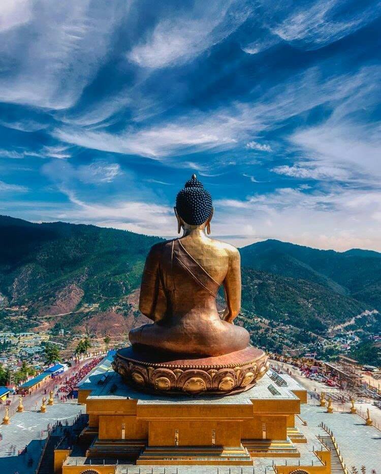
After reaching Thimphu, visit Buddha point (Large Buddha statue – Buddha Dordenma) and then MemorialStupa.
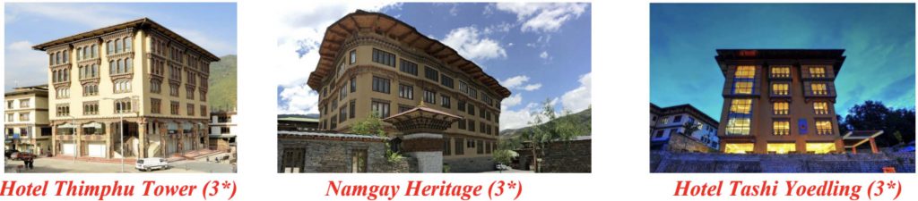
Overnight in hotel/resort at Thimphu
After the breakfast drive to Paro for the onward departure.
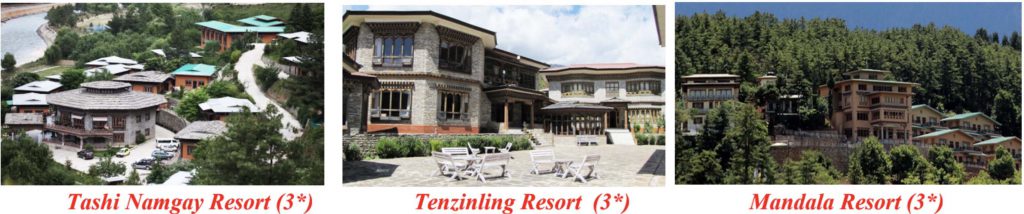
• Deluxe rooms on twin sharing basis.
• Meals (Breakfast; Lunch; Dinner, Tea/Coffee with snacks as and when required)
• Accommodation in the best 3-4 star Resorts/hotels in Bhutan.
• Brand new Bus, SUVs’ (not exceeding 4-5 years)
• 1 complimentary Bhutan air ticket if group exceeds 17 Pax
• Tea, coffee and snacks during the long drive and tour.
• Complimentary 1 Hour cultural program and farewell dinner for 8 plus pax.
• All Trekking Equipments (2 men sleeping tents, Kitchen Tents, Dining tents, Toilet Tents, Cooking Utensils etc.
• Trekking Guide and trekking cook along with supporting staffs
• Medical Facilities on free of cost (consulting doctors & medicine)
• Mineral water on long trips both on trek and cultural tours
• Museum fees and other special entry fees.
• A sustainable tourism Royalty of $65. This Royalty goes towards free education, free healthcare, poverty alleviation, along with the building of infrastructure.
• Airfare
• Laundry/Drinks / Telephone calls and any personal expenses.
• Travel Insurance (Recommended but not available in Bhutan)
• Excess baggage charges.
• Single room supplement USD$40 per night.
• Tips and Gratuities