Trekking

Trans Bhutan Trail

  • 36 days
  • Challenging

Overview

September 28, 2022. His Royal Highness Prince Jigyel Ugyen Wangchuck, Representative of His Majesty the King and the President of Bhutan Olympic Committee formally inaugurated the Trans Bhutan Trail today at a ceremony held at the historic Semtokha Dzong.
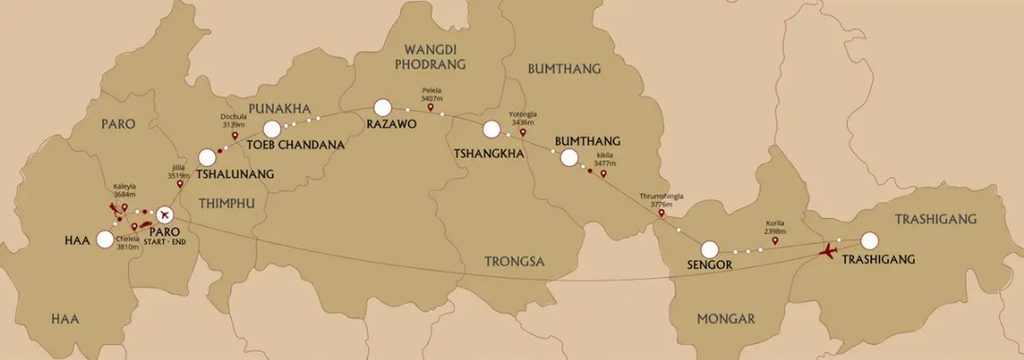
The restoration of the Trans Bhutan Trail was conceived by His Majesty the King to revive and promote Bhutan’s ancient trail, known as the zhung lam. The trail spans 403kms across the country through 9 Dzongkhags, 27 Gewogs, and 2 national parks – Phrumsengla National Park and Jigme Singye Wangchuck National Park.


His Excellency The Prime Minister, Honourable Speaker of the National Assembly, Honourable Chairman of the National Council, Cabinet Ministers, and other dignitaries also joined the occasion. The Prime Minister led a hike from Semtokha Dzong to Punakha, covering over 35 kilometres of the Trans Bhutan Trail section. The restoration of the Trail was supported by the Bhutan Canada Foundation and its founder Mr. Sam Blyth in partnership with the Tourism Council of Bhutan. Over 900 individuals across including De-Suups, Scouts, tourism sector professionals, villagers from the community and various government institutions and corporate agencies contributed to the effort.


Coinciding with the inauguration of the Trail, a group of 24 young Scouts are also hiking the entire length of the Trail – a feat that will take them 35 days. The Scout Walk will incorporate nature-based education experiences, develop leadership and teamwork skills, support local communities through voluntary activities, and contribute to nation building. Besides being an important symbol of national unity and a living cultural heritage, the Trans Bhutan Trail also provides an opportunity to contribute to the tourism sector. Recently, the Trans Bhutan Trail was listed in TIME Magazine’s World’s Greatest Places to Visit in 2022 – highlighting unique travel destinations to visit across the globe. It has also won awards for sustainability and community engagement.


The Trans Bhutan Trail aims to help rebound Bhutanese tourism in the post-pandemic market. The Trail contributes to the expansion of sustainable and responsible tourism by encouraging repeat visits, community-based experiences, wider seasonality, and eco-tourism.


The Trans Bhutan Trail also launched its Membership Program, which contributes directly to the sustainability of the trail. There are two types of memberships – Institutional Membership and Individual Membership. Starting at only Nu. 300 per person per year, the membership allows every Bhutanese and all friends of Bhutan to become stewards of this important cultural heritage. As a part of the membership program, all members will receive a TBT Trail Passport to document and log their trail exploration and adventures. It will help members track their journey in the footsteps of their ancestors across the nation.

With over 70 TBT ambassadors across the trail, users can get their passports stamped for each gewog they pass through. In addition to stamping the Trail Passports, the ambassadors are also key to delivering an authentic local experience to all trail users. Ambassadors belong to the local community and are shopkeepers, farmers, hoteliers and homestay owners, ready to help all travellers and share their stories of local legends. “I am excited to welcome travellers to Chungseykha. We hope to not only share our stories, but also learn about the guests and their culture,” said Ap Passang Wangdi, a TBT ambassador in Phangyuel Gewog in Wangdue Phodrang.

Other benefits of membership include opportunities to plant trees along the trail, discounts on Trans Bhutan Trail partner locations and TBT merchandise, invitation to all TBT events, and members-only hikes along the trail.

“Together we can commit to maintaining and enhancing this ancient trail out of respect to the ancestors who built it, and as a gift to the future generations,” said Sonam Rinchen, the Senior Project Director. “Trans Bhutan Trail is an important part of our history. It is a national symbol of unity, it is our cultural heritage and it belongs to every Bhutanese. The membership program is an opportunity for all citizens to take ownership of this ancestral trail.”

For more information, you can visit www.transbhutantrail.com
Highlights

  • DAY 1: PARO AIRPORT – HAA VALLEY
  • DAY 2: ORIENTATION HIKE IN HAA
  • DAY 3: KATSHO VILLAGE – NGOPA VILLAGE
  • DAY 4: NGOPA VILLAGE – DAMCHENANG VILLAGE
  • DAY 5: DAMCHENANG VILLAGE – TSALUNANG VILLAGE
  • DAY 6: TSALUNANG VILLAGE – BUDDHA DORDENMA
  • DAY 7: BUDDHA DORDENMA – HONGTSHO VILLAGE
  • DAY 8: HONGTSHO VILLAGE – THINLEYGANG VILLAGE
  • DAY 9: THINLEYGANG VILLAGE – PUNAKHA DZONG
  • DAY 10: REST DAY IN PUNAKHA VALLEY
  • DAY 11: PUNAKHA DZONG – LINGMUKHA VILLAGE
  • DAY 12: LINGMUKHA VILLAGE – SAMTENGANG VILLAGE
  • DAY 13: SAMTENGANG VILLAGE – RAZAWO VILLAGE
  • DAY 14: RAZAWO VILLAGE – LONGTEY VILLAGE
  • DAY 15: LONGTEY VILLAGE – CHENDEBJI VILLAGE
  • DAY 16: CHENDEBJI VILLAGE – TSHANGKHA VILLAGE
  • DAY 17: TSHANGKHA VILLAGE – KEWATHANG VILLAGE
  • DAY 18: KEWATHANG VILLAGE – GEYTSA VILLAGE
  • DAY 19: GEYTSA VILLAGE – JAKAR VALLEY
  • DAY 20: JAKAR VALLEY – PHOMDRONG VILLAGE

Day by day

Day 1 PARO AIRPORT – HAA VALLEY

On arrival at Paro International Airport today, you will be met by your guide. You will be driven by private vehicle to the town of Haa, with a brief stop en route to take in some breathtaking Himalayan vistas at Chelela, a mountain Pass which at 3,810 meters (12,500 feet) above sea level is the highest paved road in Bhutan. As you arrive at Chelela, you may wish to join with your guide and driver in a hearty cry of ‘lha-geh lu!’ (‘May the Gods be victorious’).
Your guide will select a local restaurant in Haa for dinner this evening, which will be your first chance to learn about and sample Bhutanese cuisine.

Accommodation: Soednam Zingkha Heritage Lodge or similar (3*)
Meals Included: Dinner

Day 2 ORIENTATION HIKE IN HAA

After breakfast this morning, join your guide for an acclimatization walk around the town. Your orientation walk will include a visit to the Lhakhang Karpo or ‘White Chapel’ complex, just south of Haa’s dzong (fortress). The Lhakhang has an atmospheric central chapel which houses statues of the Tse-la-nam Sum trinity. During your visit to the Lhakhang Karpo, you will have the option of a traditional pre-expedition blessing in preparation for your upcoming journey along the Trans Bhutan Trail.
The afternoon will be at leisure to relax or undertake some more gentle acclimatization walks with your guide.
Included Activities:
• Haa orientation hike
• Visit Lhakhang Karpo (temple)
Accommodation: Soednam Zingkha Heritage Lodge or similar (3*)
Meals Included: Breakfast, Lunch, Dinner

Day 3 KATSHO VILLAGE – NGOPA VILLAGE

After breakfast at your hotel, you will be transferred to Katsho, where you will begin your first day of trekking on the ancient Trans Bhutan Trail. For generations, the people of Haa followed the route you will walk today to trade with the Parops in the neighbouring valley. There, they would barter 20 drey (approximately 30 kilograms or 66 pounds) of Shakam (dried meat) for 20 drey of rice at Paro Tshongdu (market) because the harsher climatic conditions in Haa are unsuitable for rice cultivation.
The age-old trail follows the beautiful Haa river as it gently rises out of the Katsho Valley, passing through yak pastures before heading into forests of pine and rhododendron. As you traverse the Katsho Valley, look out for cliff-edge Bjungneydra Taktsang (monastery), also known as “The Mini Taktsang”, and the sky burial site of Kungkarpo. The trail continues to climb until it reaches the Pass at Kaleyla, where it crosses the ridge trail between Chelela and Sagala.
At Kaleyla, you will enjoy stunning views of the Himalayan range to the north, including on the clearest days vistas of Mount Jhomolhari (7,326m/24,036ft), Mount Jichudrakey (6,662m/21,860ft) and Mount Tsherimgang (6,532m/21,431ft). You will be provided with a picnic lunch during this stop.
From Kaleyla, the trail descends through rhododendron and bamboo forest into the Paro Valley. The last few kilometres to Paro will then be on tracks which meander through traditional Bhutanese farming villages.
On arrival, check into your hotel where your guide will arrange for dinner either at your hotel or in a local restaurant.
Trek Distance: 14.3 kilometres (8.9 miles)
Estimated Trek Duration: 6 – 7 hours
Elevation Gain: 895 metres (2,936 feet)
Elevation Loss: 1,245 metres (4,085 feet)
Starting Elevation: 2,772 metres (9,095 feet)
Ending Elevation: 2,375 metres (7,792 feet)
Maximum Elevation: 3,684 metres (12,087 feet)

Included Activities:
• Hike on the Trans Bhutan Trail
Accommodation: Metta Resort & Spa or similar (3*)
Meals Included: Breakfast, Lunch, Dinner

Day 4 NGOPA VILLAGE – DAMCHENANG VILLAGE

After breakfast this morning, rejoin the Trans Bhutan Trail heading east. The trail rises gently from Lamgong Village as it traverses the sprawling rice paddies of the Paro Valley, before carving around the northern ridge and descending into the traditional village of Dopshari. At Dopshari, enjoy a cookery demonstration and a traditional Bhutanese lunch at a local farmhouse. After lunch, you will also have the opportunity to try your hand at Bhutan’s national sport, archery, and have a quick game of traditional ‘khuru’ (darts).
After lunch, head out onto the trail for one last time for the climb up to Upper Dopshari (Damchenang), where you will end you hike with stunning views out over the Paro Valley.
Head to your hotel, where we recommend you to relax and unwind.
Trek Distance: 14.92 kilometres (9.27 miles)
Estimated Trek Duration: 7 – 8 hours
Elevation Gain: 758 metres (2,487 feet)
Elevation Loss: 301 metres (988 feet)
Starting Elevation: 2,375metres (7,792 feet)
Ending Elevation: 2,830 metres (9,285 feet)
Maximum Elevation: 2,830 metres (9,285 feet)

Included Activities:
• Hike on the Trans Bhutan Trail
• Cookery demonstration
• Archery and khuru (darts) session
Accommodation: Metta Resort & Spa or similar (3*)
Meals Included: Breakfast, Lunch, Dinner

Day 5 DAMCHENANG VILLAGE – TSALUNANG VILLAGE

After breakfast today, rejoin the Trans Bhutan Trail heading east towards Tsalunang. Today’s trek begins with a climb from Upper Dopshari through community reforestation projects, small farming villages, into deep forest and along pristine rivers. You may well find the perfect spot to hoist some lungdhar (prayer flags) on your way.

After a picnic lunch at the Pass at Jela, if time permitting, you may wish to make the small detour to visit Jela Dzong (fortress). Built on the site where Zhabdrung Ngawang Namgyel is said to have encountered the protective deity Pal Yeshey Goenpo on his pilgrimage to Paro, its main relics are the statues of Du Sum Sangye (Buddha of the Past, Present and the Future). It is believed that the Buddha once faced northwards but then miraculously turned itself to face southwest towards Paro.

From Jela, the trail drops gently down into the Tsalunang Valley, passing through forests of blue pine and rhododendron on its way. Bird watching enthusiasts will want to keep an eye out for some of Bhutan’s beautiful species on this section.

A dinner prepared from organic, locally-sourced produce will be provided at camp.
Trek Distance: 12.81 kilometres (7.96 miles)
Estimated Trek Duration: 7 – 8 hours
Elevation Gain: 770 metres (2,526 feet)
Elevation Loss: 812 metres (2,664 feet)
Starting Elevation: 2,830 metres (9,285 feet)
Ending Elevation: 2,777 metres (9,111 feet)
Maximum Elevation: 3,473 metres (11,395 feet)

Included Activities:

  • Hike on the Trans Bhutan Trail

Accommodation: Deluxe Camping
Meals Included: Breakfast, Lunch, Dinner

Day 6 TSALUNANG VILLAGE – BUDDHA DORDENMA

After breakfast at camp, continue your hike east towards Bhutan’s capital city, Thimphu. With elevations ranging between 2,248 metres (7,375 feet) and 2,648 metres (8,688 feet) above sea level, Thimphu is the fifth highest capital city in the world by altitude. It is also the only capital city in the world without any traffic lights. The city offers a unique blend of the modern world with Bhutanese tradition.
From Tsalunang, the trail climbs through forests of fir, blue pine, dwarf rhododendron and through yak pastures before it reaches the Pass at Pumola, which, at 3,994 meters (13,104 feet) above sea level, is the highest point on the Trans Bhutan Trail. Herders from Punakha would once bring their cattle here over the summer to escape the heat of the lower-lying Punakha valley.
After enjoying a picnic lunch and excellent mountain views at Pumola Thabzakha, rejoin the trail as it meanders down through picturesque meadows, offering stunning views of the Thimphu Valley from the long ridge thereafter. From here, you will be able to make out your route for the next few days in the distance beyond Thimphu. Towards the end of the day, you will arrive at Buddha Point, home to Thimphu’s most recognized landmark, the Buddha Dordenma. Guarding the entry to the Thimphu Valley, this 51 metres (167 feet) gilded bronze statue is filled with 125,000 miniature statues and sits atop a three-storey base housing a chapel and thousands of donated statuettes. The statue was commissioned to mark His Majesty the Fourth King of Bhutan, Jigme Singye Wangchuck’s 60th birthday.

Check in to your hotel before heading out for dinner with your guide at one of the many excellent restaurants in the capital.
Trek Distance: 17.53 kilometres (10.89 miles)
Estimated Trek Duration: 7 – 8 hours
Elevation Gain: 1,197 metres (3,927 feet)
Elevation Loss: 1,373 metres (4,505 feet)
Starting Elevation: 2,777 metres (9,111 feet)
Ending Elevation: 2,609 metres (8,560 feet)
Maximum Elevation: 3,994 metres (13,104 feet)

Included Activities:
• Hike on the Trans Bhutan Trail
• Visit Buddha Dordenma
Accommodation: Tashi Yoedling or similar (3*)
Meals Included: Breakfast, Lunch, Dinner

Day 7 BUDDHA DORDENMA – HONGTSHO VILLAGE

After breakfast at your hotel, head back to Buddha Dordenma to rejoin the Trans Bhutan Trail. Before the National Highway was built, the section of the trail which you will follow today would have been a busy thoroughfare connecting Thimphu with Punakha and, beyond it, the east. From here, you will descend via the Debsi Valley. After crossing the river on the motor road bridge, you will follow the old east-west highway through the town of Babesa, until you reach Simtokha Dzong (fortress). Built in 1629 by Zhabdrung Ngawang Namgyal, the fortress is said to sit on the site where a demon once vanished into a rocky outcrop. Simtokha Dzong (fortress) is said to be the first fortress in Bhutan built to house both administrative and monastic residents, and it is also the oldest dzong to have survived as a complete structure. The Dzong boasts many fine murals, carvings and tapestries, a three-storey utse (tower), and a number of chapels.
From Simtokha, the trail continues to rise steadily as it traverses orchards, strawberry fields, and market gardens. Upon arrival in Hongtsho, end your hike for the day and join the vehicle to drive back to the hotel.
Dinner will be at your hotel this evening.
Trek Distance: 20 kilometres (12.43 miles)
Estimated Trek Duration: 7 – 8 hours
Elevation Gain: 570 metres (1,870 feet)
Elevation Loss: 399 metres (1,309 feet)
Starting Elevation: 2,609 metres (8,560 feet)
Ending Elevation: 2,780 metres (9,121 feet)
Maximum Elevation: 2,780 metres (9,121 feet)

Included Activities:
• Hike on the Trans Bhutan Trail
Accommodation: Tashi Yoedling or similar (3*)
Meals Included: Breakfast, Lunch, Dinner

Day 8 HONGTSHO VILLAGE – THINLEYGANG VILLAGE

After breakfast at hotel, head back up to Hongtsho, from where the branches off into dense forest and across meadows. Eventually, the trail will reach Dochula, a mountain Pass at 3,116 metres (10,224 feet) above sea level. Mountain passes are some of the most sacred places in Bhutan and so it is customary to burn incense as an offering in places such as this. You may also wish to join locals in hanging colourful prayer flags as a sign of respect to the Gods.
Dochula offers one of the most spectacular sunrises anywhere in Bhutan and so we recommend rising early this morning. At clearer times of the year, you enjoy panoramic views of the Himalayan range in the distance as the sun rises. You should also visit the Druk Wangyal Chorten (stupa), also known as the ‘108 Chortens’, and its nearby meditation caves.
After a short break at the Pass, embark on a historic journey and head down into the adjacent valley and join a section of the Trail known as the ‘Divine Madman Trail’. You are now following in the footsteps of the Divine Madman himself, Drukpa Kuenley, when he came to Bhutan from Tibet in the 16th century to fulfil his destiny of suppressing evil energies. Over the coming days, you will come across a number of important cultural sites and extraordinary stories related to the life of Drukpa Kuenley.
You will make a stop for a picnic lunch at Lumitsawa before continuing down towards Thinleygang Lhakhang (temple).
Upon arrival, head to your campsite where a dinner prepared from organic, locally-sourced produce will be provided at camp.
Trek Distance: 12.88 kilometres (8 miles)
Estimated Trek Duration: 6 – 7 hours
Elevation Gain: 436 metres (1,431 feet)
Elevation Loss: 1,404 metres (4,607 feet)
Starting Elevation: 2,780 metres (9,121 feet)
Ending Elevation: 1,770 metres (5,807 feet)
Maximum Elevation: 3,116 metres (10,224 feet)

Included Activities:
• Hike on the Trans Bhutan Trail
• Visit Druk Wangyal Chorten (stupa)
Accommodation: Deluxe Camping
Meals Included: Breakfast, Lunch, Dinner

Day 9 THINLEYGANG VILLAGE – PUNAKHA DZONG

After breakfast this morning, head down towards Toeb Chandhana to complete the destiny of the Divine Madman. Upon arrival, if time permits visit the Toeb Chandhana Lhakhang also known as the Chandhana Lhakhang, meaning ‘where the arrow landed’. Legend has it that when Drukpa Kuenley fired an arrow from Tibet to determine his course, it landed here in Toeb Chandhana. The temple itself was built in the 15th century to ward off the evil energy of a demoness and then served as the religious seat of Ngawang Chogyal. The two hills at each end of the temple resemble knees and are said to be the knees of Ngawang Chogyal herself.
Next door to the Temple is the house of Toeb Tshewang, which Drukpa Kuenley’s arrow is said to have struck when it landed. Legend has it that, dressed as a hunting beggar, Kuenley courted Tshewang’s wife and that, in a fit of jealous rage, Tshewang drew a sword which Drukpa Kuenley miraculously knotted. Thus, Realizing Kuenley’s divine power, Tshewang offered him his wife as a gift to aid him in fulfilling his prophecies. The building still houses the eleven-stepped wooden ladder that Kuenley’s arrow is said to have struck; and the descendants of Tshewang have preserved the house as a monument for fifteen generations.
After the visit, bid farewell to Toeb Chandhana as you commence the ascent towards Sew Drangsa. In recent years, the central monastic body occasionally uses this route to reach its winter residence in Punakha and to return to Thimphu in the summer. At Sew Drangsa, you will find a clearing marked with prayer flags, which is where the monks stop for lunch en route, as you will do today. From here, the trail descends towards Punakha Dzong (fortress), offering spectacular views of the Punakha Valley on the way.
After checking into your hotel, enjoy dinner with your guide at a local restaurant.
Trek Distance: 14.71 kilometres (9.14 miles)
Estimated Trek Duration: 6 – 7 hours
Elevation Gain: 196 metres (643 feet)
Elevation Loss: 777 metres (2,549 feet)
Starting Elevation: 1,770 metres (5,807 feet)
Ending Elevation: 1,288 metres (4,226 feet)
Maximum Elevation: 1,821 metres (5,975 feet)

Included Activities:
• Hike on the Trans Bhutan Trail
• Visit Toeb Chandhana Lhakhang (temple)
Accommodation: The Four Boutique or similar (3*)
Meals Included: Breakfast, Lunch, Dinner

Day 10 REST DAY IN PUNAKHA VALLEY

Today, enjoy a full day of rest in the beautiful and charming town of Punakha starting with a visit to Punakha Dzong (fortress) which rests majestically across the Bazam (bridge). Once on the other side, enjoy a tour of the Dzong (fortress), which was built by Zhabdrung Ngawang Namgyal in around 1637 at the confluence of the Phochhu (male river) and the Mochhu (female river). Arguably, it is the most beautiful Dzong in the country. The Dzong guards Bhutan’s most treasured relic, the Rangjung Kharsapani, an image of Chenresig kept away from the public in the utse (tower). It has survived Tibetan invasions, numerous fires, floods and a glacial lake burst. The Dzong served as the capital and seat of the Bhutanese Government until the early 1950s; and the coronation of His Majesty the First Druk, Gyalpo Ugyen Wangchuck, took place here. The building currently serves as the winter residence for the monastic body.
Included Activities:
• Visit Punakha Dzong (fortress)
• Punakha sightseeing tour
Accommodation: The Four Boutique or similar (3*)
Meals Included: Breakfast, Lunch, Dinner

Day 11 PUNAKHA DZONG – LINGMUKHA VILLAGE

After breakfast at your hotel, rejoin the trail, this time heading east towards Lingmukha. Initially, the trail winds through paddy fields and then climbs relatively steeply until reaching a chorten (stupa) which marks the highest point on today’s hike. Enjoy a picnic lunch and scenic views of the valleys to the north here.
After lunch, the trail leads into the pretty Lingmukha valley, with the last hour or so of today’s hike being along the feeder road. The valley is commonly referred to as Lingmup Sher gi Zhom, which translates as “the golden bowl”, on account of the many rice fields which lie beneath ridges to either side. Here, you will visit the Lingmukha Lhakhang (temple), built by the great discoverer of treasure Terton Dorjee Lingpa. Oral tradition has it that Dorjee Lingpa arrived in Lingmukha in the 4th century, built the Lhakhang and then settled there along with his disciples. The Great Master is said to have discovered many ters (treasures) in the village.
After your visit to the temple, head to your campsite. A dinner prepared from organic, locally-sourced produce will be provided at camp.
Trek Distance: 12 kilometres (7.46 miles)
Estimated Trek Duration: 6 – 7 hours
Elevation Gain: 948 metres (3,110 feet)
Elevation Loss: 81 metres (266 feet)
Starting Elevation: 1,288 metres (4,226 feet)
Ending Elevation: 2,147 metres (7,044 feet)
Maximum Elevation: 2,147 metres (7,044 feet)

Included Activities:
• Hike on the Trans Bhutan Trail
• Visit Lingmukha Lhakhang (temple)
Accommodation: Deluxe Camping
Meals Included: Breakfast, Lunch, Dinner

Day 12 LINGMUKHA VILLAGE – SAMTENGANG VILLAGE

fter breakfast at camp, rejoin the trail heading east towards Samtengang. Historically, this section of the trail would have often been used by natives of Lingmukha and the people of Phangyul in the adjacent valley. Although the two villages are separated by a steep ridge, they strongly believe themselves to be close blood relatives who share the same cultural roots. The trail rises from deep in the Lingmukha Valley, climbing steeply through dense forest until it reaches a rest stop built at a ridge-top. From the ridge-top, you will descend sharply, enjoying panoramic views of the Shar Valleys. Stop on the way to visit the Chungse Azhe Gyalzom Lhakhang (temple) if time permits, which is built on the place where a Chan-do (a small, disc-like stone), thrown by the Divine Madman, Lam Drukpa Kuenley from Sha Kuenzangling on the other side of the valley, is said to have landed. Nearby, in the small village of Chungseykha, you will enjoy a hot lunch served in a local restaurant.
After lunch, the trail will pass by small farming villages perched on steep slopes and Lhakhang Thangkha (temple) as it climbs towards Samtengang, where you will find your campsite set up for overnight. This temple is thought to be one of the eight lings (meditation and teaching locations) of Kunkhyen Longchen Rabjam.
At the campsite, enjoy a dinner prepared from organic, locally-sourced produce will be provided.
Trek Distance: 13.85 kilometres (8.61 miles)
Estimated Trek Duration: 7 – 8 hours
Elevation Gain: 935 metres (3,068 feet)
Elevation Loss: 1,133 metres (3,717 feet)
Starting Elevation: 2,147 metres (7,044 feet)
Ending Elevation: 1,950 metres (6,398 feet)
Maximum Elevation: 2,462 metres (8,078 feet)

Included Activities:
• Hike on the Trans Bhutan Trail
Accommodation: Deluxe Camping
Meals Included: Breakfast, Lunch, Dinner

Day 13 SAMTENGANG VILLAGE – RAZAWO VILLAGE

After breakfast at camp, head out on what is a historically very significant section of the trail once used by the famous messenger Garp Lunghi Khorlo and the famous Chamberlin Pemi Tshewang Tashi. It is also an isolated section which passes through no human settlements, allowing you to be at one with nature for the duration of the day. As you head out of Samtengang, the first section of the trail is an ascent, after which the trail flattens out before dropping down towards Razawo at the end of the day. At Razawo, visit the chorten (stupa), thought to have been built in the time of Buddha Kashyapa and to be one of the oldest in Bhutan.
Head to your campsite after visiting the chorten. A dinner prepared from organic, locally-sourced produce will be provided.
Trek Distance: 16.24 kilometres (10.09 miles)
Estimated Trek Duration: 7 – 8 hours
Elevation Gain: 800 metres (2,625 feet)
Elevation Loss: 855 metres (2,805 feet)
Starting Elevation: 1,989 metres (6,526 feet)
Ending Elevation: 1,934 metres (6,345 feet)
Maximum Elevation: 2,798 metres (9,180 feet)

Included Activities:
• Hike on the Trans Bhutan Trail
• Visit Razawo Chorten (stupa)
Accommodation: Deluxe Camping
Meals Included: Breakfast, Lunch, Dinner

Day 14 RAZAWO VILLAGE – LONGTEY VILLAGE

After breakfast at camp, head out on the trail, which follows the river for a short while after leaving Razawo. From here, the remainder of the day involves a sustained climb towards the Pelela (mountain Pass). The trail will initially follow a farm road before crossing over into open meadow and forests of oak and walnut with the trail leading towards Rida village. The most important part of this village is the temple with the main relic being Sangay Tsepadme, the Buddha of Longevity, cast in bronze, which faces Pelela. Legend says that this statue was built by a young monk, the son of a local infertile couple who were blessed with the child by a tesmpa (Buddhist practitioner) in return for their kindness.
From the temple, the trail climbs up to Pelela through charming rhododendron forest. At 3,413 metres (11,198 feet) above sea level, the Pass is one of Bhutan’s highest and is traditionally considered the boundary between west and central Bhutan. Local craftspeople often sell fine yak-hair products at the roadside here.
Enjoy a picnic lunch at the Pass and then continue back on the trail descending down to the meadows of Longtey below Pelela. Upon arrival, head to your campsite and you will be able to enjoy a dinner prepared from organic, locally-sourced produce will be provided.
Trek Distance: 15.7 kilometres (9.76 miles)
Estimated Trek Duration: 6 – 7 hours
Elevation Gain: 1,488 metres (4,882 feet)
Elevation Loss: 245 metres (804 feet)
Starting Elevation: 1,934 metres (6,345 feet)
Ending Elevation: 3,174 metres (10,414 feet)
Maximum Elevation: 3,413 metres (11,198 feet)

Included Activities:
• Hike on the Trans Bhutan Trail
Accommodation: Deluxe Camping
Meals Included: Breakfast, Lunch, Dinner

Day 15 LONGTEY VILLAGE – CHENDEBJI VILLAGE

After breakfast at your camp, head back on to the Trans Bhutan Trail. As you descend through the meadows, keep an eye out for the remote yak herder camps which can be seen scattered around the valley. Stop in a traditional farmhouse in the village of Rukubji to enjoy a hot lunch, before visiting Rukubji’s village Lhakhang (temple), also known as Kuenzang Choling. It is thought that this temple was built some 300 years ago by a Lama named Tshendhen Duelwa. Unlike most temples, it is not built on a ridge with a view out over a valley, but rather on an extended plateau and close to two rivers: the reason for this is that the Lama is said to have built the temple on top of the head of a snake-demoness which he subdued in the same location. Rukubji is also famous for its unique local language, and you will have the chance to learn about it from the villagers over tea. The dialect, called Ngyen-Kye, is a mix of other dialects from across Bhutan and even some English words, and is now only spoken by a dozen or so households.
In the afternoon, rejoin the trail for a gentle climb out of the valley and through a forest, before dropping back down to the village of Chendebji, where you will camp for the night. At Chendebji, visit the Chorten (stupa), which is built at the point on which it is believed that the three ridges and the three edges of the sky meet. The Chorten was built by Lam Ngedup Tshering Wangchuk in order to subdue a local demoness, Nyala Dudm, and bring peace to the Chendebji Valley.
Enjoy a locally-sourced organic dinner at the campsite.
Trek Distance: 16.04 kilometres (9.97 miles)
Estimated Trek Duration: 6 – 7 hours
Elevation Gain: 249 metres (817 feet)
Elevation Loss: 930 metres (3,018 feet)
Starting Elevation: 3,174 metres (10,414 feet)
Ending Elevation: 2,470 metres (8,104 feet)
Maximum Elevation: 3,174 metres (10,414 feet)

Included Activities:
• Hike on the Trans Bhutan Trail
• Lunch at Traditional Farmhouse
• Visit Rukubji Lhakhang (temple)
Accommodation: Deluxe Camping
Meals Included: Breakfast, Lunch, Dinner

Day 16 CHENDEBJI VILLAGE – TSHANGKHA VILLAGE

After breakfast at your camp, rejoin the trail at the Chendebji Chorten (stupa). You will follow the old East-West National Highway for a short while, before heading back deep into the countryside towards the village of Tangsibji. A hot lunch will be served at a farmhouse in Tangsibji.
Today, the trail route passes the sites of several hydroelectric projects. These clean, renewable energy projects are one of the ways in which Bhutan has achieved its status as the only carbon negative country in the world. Bhutan also exports large amounts of green energy to neighbouring India. You will also have the chance to visit the Trashichoeling Lhakhang (temple), located in Trashiling village. The temple was built in 2002 as an offering to His Majesty the Fourth King of Bhutan by His Holiness the 70th Je Khenpo.
On arrival in Tshangkha, time permitting visit the Tshangkha Lhakhang (temple) before heading to your campsite. The ground on which the temple stands is thought to have been first blessed on an unknown date by Lopen Golay of Tshangkha, who gained his wisdom and power from the mantras of the Mindroling monastery in Tibet. The first structure was built here in 1701 by Choezang, who served as the Trongsa Chamberlain, and the site now provides a venue for both social and religious community gatherings.
After your visit, enjoy a locally-sourced organic dinner at the campsite.
Trek Distance: 22.52 kilometres (14 miles)
Estimated Trek Duration: 7 – 8 hours
Elevation Gain: 316 metres (1,037 feet)
Elevation Loss: 444 metres (1,457 feet)
Starting Elevation: 2,470 metres (8,104 feet)
Ending Elevation: 2,278 metres (7,474 feet)
Maximum Elevation: 2,470 metres (8,104 feet)

Included Activities:
• Hike on the Trans Bhutan Trail
• Visit Chendebji Chorten (stupa)
Accommodation: Deluxe Camping
Meals Included: Breakfast, Lunch, Dinner

Day 17 TSHANGKHA VILLAGE – KEWATHANG VILLAGE

After breakfast at your camp, head back out onto the trail for the short, steep climb out of Tshangkha, past the Ugyen Choling and Tsangkha Sheydra. The Trail then drops back down towards the National Highway, which it crosses at the Trongsa viewpoint.
Trongsa is Bhutan’s geographical center point and is very closely linked to the Bhutanese Royal Family: the first two hereditary Kings ruled from Trongsa Dzong (fortress) and the crown prince still traditionally serves as the Penlop (Governor) of Trongsa before acceding to the throne. The Trans Bhutan Trail still passes directly through the middle of the city of Trongsa and, in centuries gone by, the trail would actually have passed right through Trongsa Dzong itself. Today you will recreate the experience of arriving at this powerful city on foot in the same way the garps (messengers) would have done centuries ago, as you descend into the steep valley below the viewpoint, enjoying spectacular views of the Dzong (fortress) on the opposite side. At the bottom of the valley, you will cross the old cantilever bridge over the Mangde River before heading up the other side of the valley and entering Trongsa Dzong (fortress) via the Western gate.
After lunch in a local restaurant, enjoy a tour of Trongsa Dzong (fortress) and head back on the trail for a gradual climb towards Kewathang where you will end your hike for the day.
The Trongsa Dzong (fortress) was first built by Wangchuck as a small meditation room in 1541, after he discovered self-manifested hoof- prints belonging to the deity Pelden Lhamo on the same spot. Trongsa, which means ‘new village’ in the local dialect, soon sprung up around the site. The Dzong (fortress) was built in its present form in 1644 and then enlarged again at the end of the 17th century. It is home to some 450 district monks who spend their winters in Trongsa and their summers in Bumthang. You will visit a selection of the Dzong’s 23 lhakhangs (temples), before heading to the Trongsa Ta Dzong (watchtower), which now houses the interesting Royal Heritage Museum.
The remainder of the day will be at leisure to relax, before enjoying dinner with your guide at a local restaurant in the early evening.
Trek Distance: 13.01 kilometres (8.09 miles)
Estimated Trek Duration: 6 – 7 hours
Elevation Gain: 881 metres (2,891 feet)
Elevation Loss: 773 metres (2,536 feet)
Starting Elevation: 2,278 metres (7,474 feet)
Ending Elevation: 2,374 metres (7,789 feet)
Maximum Elevation: 2,435 metres (7,989 feet)

Included Activities:
• Hike on the Trans Bhutan Trail
• Visit Trongsa Dzong (fortress)
Accommodation: Deluxe Camping
Meals Included: Breakfast, Lunch, Dinner

Day 18 KEWATHANG VILLAGE – GEYTSA VILLAGE

After breakfast at your hotel, bid farewell to Trongsa, as you head back out on the trail for a gradual climb up towards Yotongla (mountain Pass). Today’s trek crosses a number of ecological zones and so is particularly rewarding for birdwatchers. From Kewathang, the trail cuts through dense forest until it reaches the Pass. Enjoy a picnic lunch en route.
From Yotongla, the trail descends through meadows and open forest until it meets the Geytsa River. The last stretch for today is a pleasant riverside walk towards Geytsa passing by the Chuchi Lhakhang (temple). Whilst there are no official records of when this temple was built, locals claim that it was one of the 108 temples built across the Himalayan region by King Songsten Gampo in the 10th century.
Enjoy a warm dinner this evening at the hotel with your guide.
Trek Distance: 19.38 kilometres (12.04 miles)
Estimated Trek Duration: 8 – 9 hours
Elevation Gain: 1,082 metres (3,550 feet)
Elevation Loss: 571 metres (1,873 feet)
Starting Elevation: 2,374 metres (7,789 feet)
Ending Elevation: 2,889 metres (9,479 feet)
Maximum Elevation: 3,427 metres (11,244 feet)

Included Activities:
• Hike on the Trans Bhutan Trail
Accommodation: Chumey Nature Resort or similar (3*)
Meals Included: Breakfast, Lunch, Dinner

Day 19 GEYTSA VILLAGE – JAKAR VALLEY

After breakfast, head out on to a historic section of the trail which would traditionally have been used by the Royal family when they transferred between Trongsa and Bumthang or Bumthang and Kuenga Rabten, where His Majesty the Second King had his summer residence. From Geytsa, the trail rises through pine forests towards the Pass at Kikila, where the trail briefly follows the route of the Owl Trek.
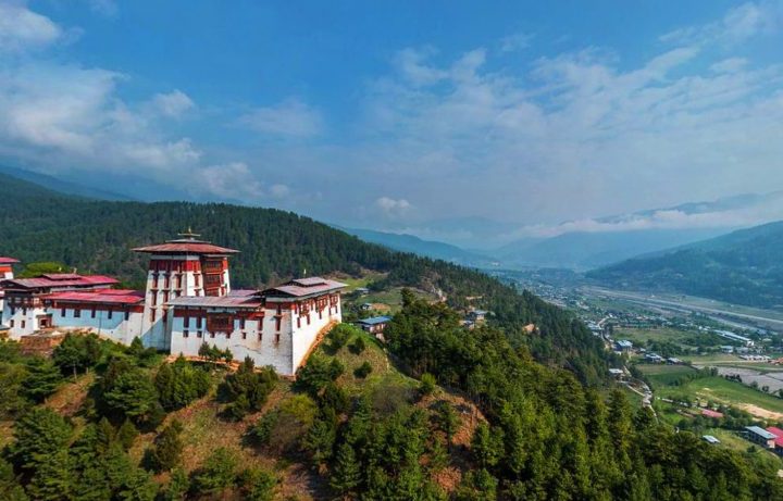
From Kiklia, the trail descends gently into the Bumthang Valley, offering spectacular views of Jakar Dzong (fortress) on the way down.
Dinner this evening will be at the hotel with your guide.
Trek Distance: 16.08 kilometres (9.99 miles)
Estimated Trek Duration: 7 – 8 hours
Elevation Gain: 667 metres (2,188 feet)
Elevation Loss: 976 metres (3,202 feet)
Starting Elevation: 2,889 metres (9,479 feet)
Ending Elevation: 2,580 metres (8,465 feet)
Maximum Elevation: 3,421 metres (11,244 feet)

Included Activities:
• Hike on the Trans Bhutan Trail
Accommodation: Yugharling Resort or similar (3*)
Meals Included: Breakfast, Lunch, Dinner

Day 20 JAKAR VALLEY – PHOMDRONG VILLAGE

After breakfast at your hotel, head east out of Bumthang through the beautiful and charming town of Chamkhar before climbing up to Badhala enjoying spectacular views of Lhodrak Karchu Dratsang (monastery). The monastery is one of the most important in Bhutan. It is believed to have been founded in 1984 by Namkhai Nyingpo Rinpoche, a descendent of a Tibetan lama whose spiritual lineage can be traced back to one of the close disciples of the great Buddhist Guru Padmasambhava. Originally, the two-story monastery was large enough to accommodate 70 monks, but has since grown considerably and is now home to over 400. The building houses a huge assembly hall with imposing statues of Guru Rinpoche and a beautiful terrace with breathtaking views of the Chhokhor Valley and Jakar Dzong.
The trail begins to descend after Badhala as you are approaching the village of Babzur and continue towards the Pema Choling Nunnery. Women and girls who enrol here follow a nine-year course in the Nyingma Peling Buddhist tradition and are known for a particular drum ceremony known as “chod”.
After your visit to the nunnery, the trail continues south towards the sacred Mebartsho (burning Lake), where, in the 15th century, the great treasure hunter Pema Lingpa is said to have discovered several of Guru Rinpoche’s hidden treasures. Lingpa had a dream in which he was summoned to this particular location on the Tang River and, when he arrived, he saw at the bottom of the river a temple with many doors, one of which was open. He then swam down into a large cave where he was handed a treasure chest by a one-eyed woman. He would later repeat the feat in the presence of the local people and whilst holding a lit butter lamp which did not go out underwater – and it is because of that that this pool was named “burning lake”.
Enjoy a nice outdoor picnic lunch before heading back towards your hotel.
Trek Distance: 14.39 kilometres (8.94 miles)
Estimated Trek Duration: 6 – 7 hours
Elevation Gain: 673 metres (2,208 feet)
Elevation Loss: 508 metres (1,667 feet)
Starting Elevation: 2,580 metres (8,465 feet)
Ending Elevation: 2,702 metres (8,865 feet)
Maximum Elevation: 3,047 metres (9,997 feet)

Included Activities:
• Hike on the Trans Bhutan Trail
• Visit Pema Choling Nunnery
• Visit Mebartsho (burning Lake)
Accommodation: Yugharling Resort or similar (3*)
Meals Included: Breakfast, Lunch, Dinner

Places you’ll visit

Make it yours

Tailor this journey with a local travel designer

Share your dates and dreams — we will reply within 24 hours with a personalised proposal.

    We reply within 24 hours. Your details are never shared.

    You may also love

    Dagala Trek with Culture Tour 9D / 8N

    Trekking

    Dagala Trek with Culture Tour

    Durations: 4 Day Trek 5 Day Culture Tour Locations : Paro, Thimphu, Punakha Highlight: During the trek an entire day will be dedicated to…

    • 9 days
    • Moderate
    • 5-10
    Druk Path Trek With Culture Tour 14D / 13N

    Trekking

    Druk Path Trek With Culture Tour

    Duration: 14 Days, 13 Nights.Locations: Paro, Jili dzong, Jangchulahakha, Jana tsho, Jangchulhakha, phajoding, Thimphu, Punakha and Wangdue valley. Highlight: The Druk Path Trek is also a…

    • 14 days
    • Moderate
    • 6-10